

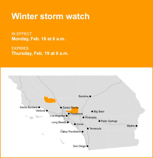
Eastern San Gabriel Mountains and Northern Ventura County Mountains are under a winter storm watch which was released by the National Weather Service on Saturday at 12:20 p.m. The watch is valid from Monday 6 a.m. until Thursday Feb. 19, at 9 a.m.
“Heavy snow possible. Total snow accumulations of 1 to 4 inches for 3500 to 4500 feet elevation possible, 6 to 12 inches for 4500 to 6000 feet elevation possible, and one to two feet above 6000 feet elevation possible. Wind gusts of 60 to 70 mph through Monday afternoon possible, and as high as 50 mph through Thursday morning possible,” the NWS Los Angeles/Oxnard CA said. “There will be a break in the snowfall for Tuesday into Tuesday night, before heavy snow returns by Wednesday. However, blowing and drifting snow producing significant visibility restrictions will continue above 6000 feet elevation, even during the break in snowfall.”
“Roads, and especially bridges and overpasses, will likely become slick and hazardous. Travel could become treacherous. Visibilities may drop below one-quarter mile due to falling and blowing snow. Damaging winds could blow down trees and power lines,” according to the NWS. “Monitor the latest forecasts for updates on this situation. If travel is absolutely necessary, drive with extreme caution and be prepared for sudden changes in visibility. Leave plenty of room between you and the motorist ahead of you, and allow extra time to reach your destination. Avoid sudden braking or acceleration, and be especially cautious on hills or when making turns. Make sure your car is winterized and in good working order. Damaging winds could blow down trees and power lines. Travel could be difficult, especially for high profile vehicles.”

Winter driving essentials: Recommendations from the NWS for safe journeys
Winter weather can make driving treacherous, leading to over 6,000 weather-related vehicle fatalities and over 480,000 injuries each year. When traveling during snow or freezing rain, prioritize safety by slowing down. In near-freezing temperatures, it’s safest to assume that icy conditions exist on roadways and adjust your driving accordingly. Be cautious of ice accumulating on power lines or tree branches, which can lead to snapping and falling hazards. If possible, avoid driving in such conditions. If you must venture out, opt for routes with fewer trees and power lines. Never touch a downed power line, and immediately dial 911 if you come across one. Here are additional winter weather driving tips:
Share your travel plans:
When venturing out of town in hazardous winter weather, be sure to inform family or friends of your destination, your intended route, and your estimated arrival time.
Prepare your vehicle:
Ensure your gas tank is full and equip your vehicle with essential winter supplies such as a windshield scraper, jumper cables, a small shovel, flashlight, cell phone, blanket, extra warm clothing, drinking water, and high-calorie non-perishable food.
Stay calm when stranded:
If you become stranded, stay composed. Notify someone about your situation and location. Avoid attempting to walk to safety. Attach a cloth to your car’s antenna or mirror to signal that you require assistance. Make your vehicle more visible by using the dome light and flashers.
Be aware of snow plows:
Keep an eye out for snow plows and provide them with ample room to pass. Only overtake a plow when you have a clear view of the road ahead.
Check road conditions:
Before embarking on your journey, verify the current road conditions to make informed travel decisions.
These winter driving tips from the NWS are your key to a safer journey on snow-covered roads. By following these guidelines, you can significantly reduce the risk of accidents and ensure your well-being during challenging winter weather.
For more local weather alerts, visit our Weather Advisory page