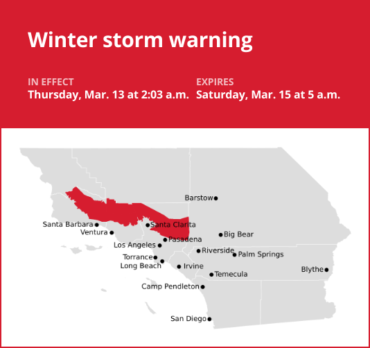
Los Angeles County is under a winter storm warning which was released by the National Weather Service on Thursday at 2:03 a.m. The warning is in effect until Saturday, Mar. 15 at 5 a.m.
“Heavy snow possible with 12 to 24 inches possible above 6500 – 7000 feet, 6 – 12 inches 5500 – 7000, 1-5 inches 4000-5500 feet, and up to an inch as low as 3000 feet. Winds could gust as high as 50 mph,” the NWS Los Angeles/Oxnard CA said. “The heaviest snow is expected to be tonight into Thursday morning. A second, and much weaker system will move into the mountains Friday into Friday night generating much lighter accumulations.”
“Travel could be very difficult. The hazardous conditions could impact the Thursday morning and evening commutes. Gusty winds could bring down tree branches,” according to the NWS. “If you must travel, keep an extra flashlight, food, and water in your vehicle in case of an emergency. The latest road conditions for the state you are calling from can be obtained by calling 5 1 1.”
The full list of affected locations includes:
- 5 Freeway corridor near Santa Clarita
- Western San Gabriel Mountains/Highway 14 Corridor
- Eastern San Gabriel Mountains
- Western Antelope Valley Foothills
- Eastern Antelope Valley Foothills
- Santa Barbara County Interior Mountains
- Southern Ventura County Mountains
- Northern Ventura County Mountains
Emergency alerts in Southern California
For “considerable or catastrophic” hazards, emergency alerts will be sent to all enabled mobile phones in the area. To monitor lesser risk, residents are advised to sign up for county alert systems and to monitor agencies’ social media. How to sign up for alerts in your area:
Mastering winter roads: Guidance from the NWS for safe winter travel
Winter’s icy grip often turns roads treacherous, leading to over 6,000 weather-related vehicle fatalities and more than 480,000 injuries each year. When you find yourself on snowy or freezing rain-slicked roads, your top priority should be safety. Slow down and exercise caution. In temperatures near freezing, it’s prudent to assume icy patches on the road and adjust your driving accordingly. Be on alert for ice accumulating on power lines and tree branches, as they may break and fall. If possible, avoid driving in these conditions altogether. But if you must venture out, choose routes with fewer trees and power lines, and never touch a downed power line. If you encounter one, dial 911 immediately. Here are additional winter weather driving tips:
Share your travel plans:
When traveling out of town in hazardous winter weather, inform your family or friends of your destination, planned route, and estimated time of arrival.
Prepare your vehicle:
Ensure your gas tank is full and equip your vehicle with essential winter supplies such as a windshield scraper, jumper cables, a small shovel, flashlight, cell phone, blanket, extra warm clothing, drinking water, and high-calorie non-perishable food.
Stay calm when stranded:
If you become stranded, remain composed. Inform someone about your situation and location. Avoid attempting to walk to safety. Indicate that you need assistance by attaching a cloth to your car’s antenna or mirror, and make your vehicle more visible by using the dome light and flashers
Be aware of snow plows:
Keep an eye out for snow plows and allow them ample room to pass. Only overtake a plow when you have a clear view of the road ahead.
Check road conditions:
Before embarking on your journey, verify the current road conditions to make informed travel decisions.
Stay safe on wintry roads with these valuable winter driving tips from the NWS, and reduce the risk of accidents during challenging weather conditions.