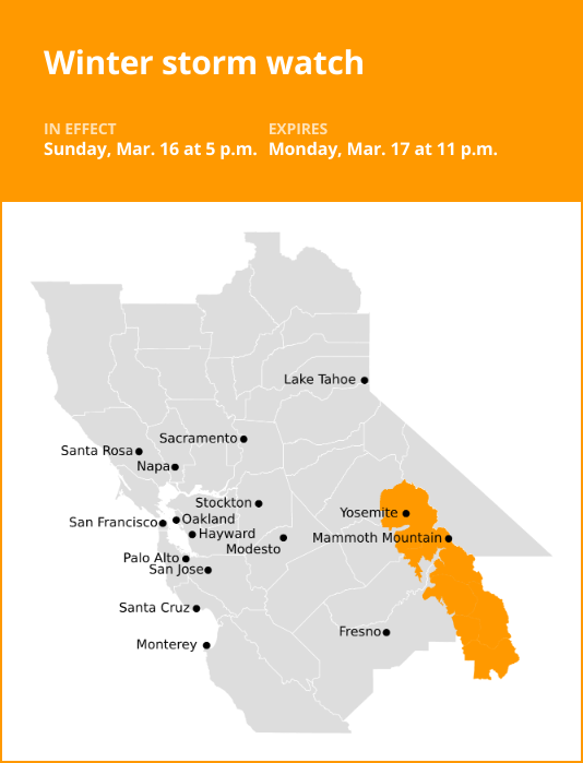
Yosemite is under a winter storm watch which was released by the National Weather Service on Saturday at 2:25 a.m. The watch is valid from Sunday 5 p.m. until Monday, Mar. 17 at 11 p.m.
According to the NWS Hanford CA, “Heavy snow possible. Total snow accumulations up to 18 inches possible. Winds could gust as high as 55 mph.”
“Travel could be very difficult to impossible. The hazardous conditions could impact the Monday morning and evening commutes. Strong winds could cause tree damage,” according to the NWS. “Monitor the latest forecasts for updates on this situation.”
The full list of affected locations includes:
- Yosemite
- Upper San Joaquin River
- Kaiser to Rodgers Ridge
- Kings Canyon NP
- Grant Grove area
- Sequoia NP
Where to find winter weather shelters in your county:
Winter weather shelters in Santa Clara County: San Jose operates the Overnight Warming Location program.
Winter weather shelters in Alameda County: List of winter shelters operated in Alameda County, from Alameda County Health Care for the Homeless.
Winter weather shelters in San Mateo County: San Mateo County residents in need of shelter should visit their local Core Service Agency in order to seek access to the Inclement Weather Program or other shelter programs.
Winter weather shelters in Contra Costa County: For information about how to connect with all emergency shelters in Contra Costa, call 211 or click on the list of shelters provided by Contra Costa Health.
Winter weather shelters in Solano County: Solano County offers a list of centers where anyone can go to keep warm during extreme weather temperatures.
Winter driving essentials: Recommendations from the NWS for safe journeys
Winter’s icy grip often turns roads treacherous, leading to over 6,000 weather-related vehicle fatalities and more than 480,000 injuries each year. When you find yourself on snowy or freezing rain-slicked roads, your top priority should be safety. Slow down and exercise caution. In temperatures near freezing, it’s prudent to assume icy patches on the road and adjust your driving accordingly. Be on alert for ice accumulating on power lines and tree branches, as they may break and fall. If possible, avoid driving in these conditions altogether. But if you must venture out, choose routes with fewer trees and power lines, and never touch a downed power line. If you encounter one, dial 911 immediately. Here are additional winter weather driving tips:
Share your travel plans:
When traveling out of town in hazardous winter weather, inform your family or friends of your destination, planned route, and estimated time of arrival.
Prepare your vehicle:
Ensure your gas tank is full and equip your vehicle with essential winter supplies, including a windshield scraper, jumper cables, a small shovel, flashlight, cell phone, blanket, extra warm clothing, drinking water, and high-calorie non-perishable food.
Stay calm when stranded:
If you become stranded, stay composed. Notify someone about your situation and location. Avoid attempting to walk to safety. Attach a cloth to your car’s antenna or mirror to signal that you require assistance. Make your vehicle more visible by using the dome light and flashers.
Be aware of snow plows:
Keep an eye out for snow plows and provide them with ample room to pass. Only overtake a plow when you have a clear view of the road ahead.
Check road conditions:
Before embarking on your journey, verify the current road conditions to make informed travel decisions.
Stay safe on wintry roads with these valuable winter driving tips from the NWS, and reduce the risk of accidents during challenging weather conditions.